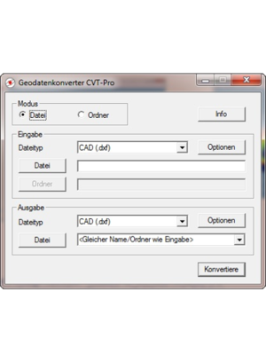
Geo-Data Converter CVT-Pro
Conversion of Measuring data
|
|
|
CVT-Pro is easy to use and features the fast and reliable conversion of various geodetic data formats.
|
Supported file formats:
- CAD DXF (import up to AutoCad 2019, export AutoCad R12)
- CST/Berger (CST)
- Geodimeter (ARE)
- Leica GSI-8 and GSI-16
- Microsoft Excel (CSV)
- REB DA11 (for area calculations in accounting software on RoboStation-XML basis)
- REB DA30, 45, 49
- RoboStation XML
- Scalable Vector Graphics (SVG)
- Sokkia SDR33
- Text with arbitrary format
- Topcon (KOR)
|
|
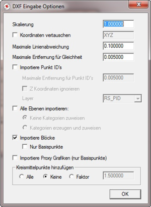
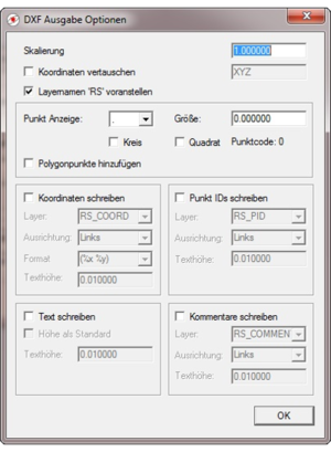
Basic object types are 3D-polygons consisting of points and edges. Object types like circles, ellipses, splines, etc. are automatically converted into corresponding 3D-polygons.
|
Available options:
- scaling
- coordinate swap
- add midpoints of circles
- add pointnumbers or coordinates as text
- Highlight polygon points
- Replacing blocks through anchor points
- and many others...
|
|
CVT-Pro supports layers well known from standard CAD software. Point- and polygon-categories (RoboStation XML-format) are supported as well.
Beyond the features of the converter’s standard version, which is delivered together with the PlanAssistant fieldbook, CVT-Pro comes along with most useful functions.
|
| Function
| CVT
| CVT Pro
|
| Multilingual |
 |
|
| Read/write RoboStation-files (XML) |
|
|
| Read/write CAD-files (DXF) |
|
|
| Read/write spread sheet-files (CSV) |
|
|
| Read/write arbitrary text format (TXT) |
|
|
| Read/write Leica GSI-8 and GSI-16 |
|
|
| Write REB DA11 for area calculation |
|
|
| Read/Write REB DA30, 45, 49 |
|
|
| Write SVG-Data |
|
|
| Command line control |
|
|
| Graphical user interface |
|
|
| Drag & Drop of files and folders |
|
|
| Tooltip-help |
|
|
| Conversion of entire folders |
|
|
| Add midpoints of circles at the DXF import |
|
|
| Read DXF blocks |
|
|
| Add point numbers in DXF |
|
|
| Read point numbers from DXF |
|
|
| Add coordinates as text in DXF |
|
|
| Add comments in DXF |
|
|
| Text output in DXF |
|
|
| Read/write surfaces in DXF (3DFACE) |
|
|
| Coordinate scaling |
|
|
| Coordinate swap |
|
|
| Definition of own formats with XSLT and AWK |
|
|
|
Most naturally, the Pro-Version (like the standard version) dovetails perfectly with our RoboStation Center software.
|
|
 Downloads Downloads
 Contact Contact
|